






Cengiz Özemli
Academic
- Thread Author
- #1
In modern manufacturing and warehouse environments, autonomous mobile robots (AMRs) and automated guided vehicles (AGVs) operate in shared spaces with pedestrians, temporary pallets, and heavy equipment. In these dynamic environments, traditional 2D laser-based positioning systems often experience bottlenecks due to blind spots, map drift, and unexpected obstacles. SIGMATEK has introduced its updated SLAMLoc software and 3D route tracking capabilities to overcome these challenges.
🗺️ Multi-Sensor SLAM and Real-Time Local Mapping
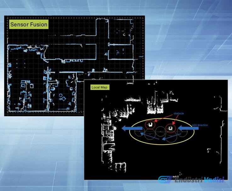
SIGMATEK's open-source, real-time positioning software, SLAMLoc, offers enhanced Simultaneous Localization and Mapping (SLAM) capabilities developed to address uncertainties in industrial environments. The software architecture includes sensor fusion algorithms that combine raw point cloud data from multiple LiDAR scanners mounted on the vehicle chassis. This allows the platform to continuously build situational awareness, optimizing vehicle trajectory calculations even in large facilities.
For local obstacle avoidance, the software offers an optional dynamic local map module called "MiniMap." This module evaluates the immediate area around the mobile base in real-time, capturing temporary ground obstacles. Instead of stopping the vehicle when an unmapped obstacle enters its travel lane, the system calculates an optimized alternative bypass trajectory, maintaining material handling cycles and minimizing unnecessary downtime.
💻 Virtual Diagnostics and Commissioning Analysis
To streamline commissioning processes, SLAMLoc includes a virtual troubleshooting module that allows for remote diagnostic assessment without requiring physical access to the mobile platform. Engineering and service teams can reconstruct historical task sequences to identify operational triggers behind vehicle stoppages, trajectory deviations, or navigation interruptions.
🛡️ Volumetric Sensing for Route Protection
Complementing contour-based SLAM, the AGV Automation Visionary 3D software solution offers three-dimensional route tracking to eliminate the typical blind spots of planar 2D LiDAR systems. The system integrates one or two SICK Visionary-T Mini cameras directly into the navigation architecture, capturing spatial point clouds along the forward path of movement.
This 3D volumetric inspection detects ground-level and overhead hazards that escape standard horizontal planar scans, including empty elevator shafts, protruding forklift forks, floor steps, and low-profile objects. The inclusion of multi-dimensional object classification enhances the safety of autonomous mobile platforms in complex manufacturing and intralogistics applications.
🔍 Technical Details
- Navigation architectures in industrial mobile robotics often balance contour-based 2D LiDAR SLAM, natural feature SLAM, and time-of-flight (ToF) 3D vision.
- Planar 2D safety laser scanners are standardized to meet ISO 3691-4 safety field requirements but cannot detect negative obstacles (such as floor drops and open pits) or overhanging loads.
- The SICK Visionary-T Mini uses 3D time-of-flight technology, capturing up to 30 three-dimensional depth frames per second with an 80° × 60° field of view on a 512 × 424 pixel matrix within a 5-meter operating range.
- The execution of local sub-maps, such as MiniMap, isolates local point cloud processing. This architecture maintains deterministic control loop times of under 50 milliseconds, enabling agile path avoidance while maintaining ISO 3691-4 personnel safety compliance in congested logistics centers.